Since starting back on site on 27 April, after a pause amidst the outbreak of COVID-19, work along Le Neubourg Way, Gillingham, has progressed well.

The new material compound area on Chantry Fields is now in operation, providing much needed extra space to store materials for the works.
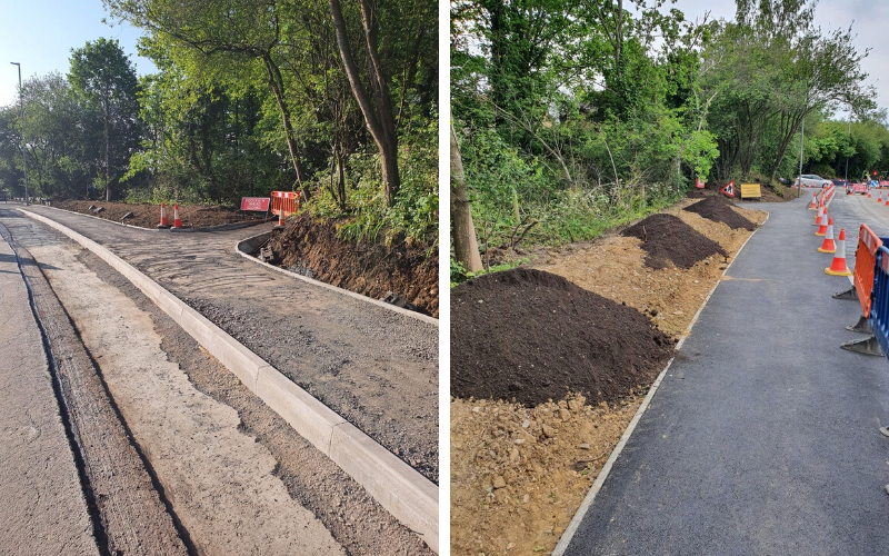
Over the last month the team on site has finished building the new cycleway on the northbound side of the road between Cemetery Road and Waitrose. Seeding of the new embankments will take place over the coming weeks.
Between Church View and Wyke Street the Rootlok System has been used for the retaining wall – providing a more natural finish.
Made in the UK, the system provides the engineering of a retaining wall while enhancing the environment. Geotextile bags are filled with a mix to support vegetation and locked together with a ‘plate’ to create a solid structure. These will naturally grow vegetation on them to create a green finish.


What’s next?
Work has now started on the southbound side of Le Neubourg Way, Gillingham, to build the cycleway from Wyke Street to Station Road, this will also include narrowing the access into Waitrose to make it easier for pedestrians and cyclists to cross at the new junction.
The current three-way temporary signals with controlled pedestrian crossings will remain in place.
Southbound footway closures, and the closure of the footpath between Le Neubourg Way and The Square, will be required during different phases of the work for safety reasons, please look out for local barriers and signage.
The cycleway construction along Le Neubourg Way is on schedule to finish by the end of July. The Waitrose Junction signals will be commissioned in the Autumn when Le Neubourg Way is resurfaced from Newbury to Wyke Street, line markings and the traffic signal loops will also be completed at this time.
These sustainable transport works will be followed with improvement works on Newbury Roundabout, Station Road and the New Road junction.
Concerns with Church View
The design of the new Waitrose Junction – with a left-turn filter lane from Le Neubourg Way – means that the island near Church View had to be removed. This layout will reduce delays to straight through traffic.
We appreciate this island was a well-used crossing point but, following highway design guidelines, it was not possible to keep it. The new crossing is only a short distance away (40m) and provides a safer, signal controlled crossing.
As part of our scheme design, the traffic modelling does not anticipate any delays for vehicles entering and exiting Church View. The traffic counts didn’t show a heavy enough right-turn into Church View to require a dedicated turn lane.
The signalised junction at Waitrose will provide natural gaps in the traffic from the all red and pedestrian crossing stages for drivers in Church View.
Vehicles on Le Neubourg Way approaching the new traffic signals at Waitrose will also be slowing down and will be more inclined to let vehicles out of Church View if they see them waiting.
About the project
£3.18m secured by Dorset Local Enterprise Partnership through the Government’s Growth Deal aims to unlock and deliver the development of up to 1,800 houses and 2,500 jobs.
Four junctions along the B3081 are being improved, as well as pedestrian and cycle facilities being provided between Cemetery Road and Station Road, and around the busy B3081 junctions through the town.
The funding is also enabling the design of Enmore Green Link Road, between the B3081 and the A30 west of Shaftesbury, as part of the Gillingham Growth Package. The project aims to significantly reduce traffic travelling through Shaftesbury to reach Gillingham.

Great to see the council working on cycle ways. Are there any plans to put in a cycle path between Sherborne and Yeovil , a very busy road which has taken the lives of several cyclists including one child back in the 1980’s ?
There is a cycle route which takes a back road but this is along a narrow country road and is used by many vehicles making the journey even more hazardous.
Took awhile to see where in N Dorset this is. As an infrequent visitor though a Dorset resident such information would help
Whilst it seems fine to introduce a segregated cycle lane what is the provision for the for the safety of walkers many of whom will be elderly and/or accompanied by young children, pushchairs etc. when having to share same ‘pathway’. Sadly we know from experience that some cyclists become ‘tearaways’ without concern for others.
Maybe this is catered for but not apparent from visiting site(s) and particularly the photographs.
Faster cyclists (like myself) will generally still use the road over a shared use path. Unfortunately, motorists seem to forget the highway code and shout things like “get on the cycle lane”…
Shared use paths cater for the less confident, who are unlikely to be travelling at significant speed.
DfT guidelines state that you should use the road at above 18 mph, but I find that anything above 10 in a town is not advisable – it would be OK on a rural shared use path like those along the A34, A40, etc, around Oxford.
Very interesting but where is this work being done? North Dorset is a big place! I guess it’s either Shaftesbury or Gillingham?
You do not name the town or show a map.
Where (i.e. in which town) are these improvements taking place? It doesn’t seem to be mentioned anywhere in the article.
“Cycleway works progressing in north Dorset” is the headline, but I do not actually know where you are talking about! The script mentions Le Neubourg Way, Wyke Street and Station Road but I am still none the wiser!
Please ensure you specify the town in question.
Apart from the council email saying this cycle way is in N Dorset there is no further clue as to where it is? Which town or village please?
Apologies everyone, this is in Gillingham. (Ten points to anyone who guessed correctly!)
I’ve now amended the article to mention the town. 🙂
Biggest waste of money ever seen. During the lockdown I have seen the Lycra lunatics forcing the elderly and family’s off the footpaths that run through Rolls Bridge and beyond in Gillingham. Well done Dorset Council. words fail me
Good for gilligham locals, look forward to connectivity in Ferndown and Wimborne, believe Sustrans had some plans for Leigh road but no where to be found?? please help
Hi Jason, yes a scheme design is being progressed for a cycleway along Leigh Road funded by the recent Transforming Cities Fund awarded jointly to us and BCP Council. As soon as there is information available for residents we will get it online.