
The censuses were incredibly useful things. Not only because of the information about the population that was learned, but for genealogists in the centuries afterwards. And yet, censuses can be hard work too. One of the most frequently asked questions we receive is how to find out exactly where someone lived as often the censuses did not give property numbers.
At this point, we should point out that for members of Dorset Libraries, Ancestry remains free until the end of September 2020. The following example comes from an enquiry we received last year!
—
“I’m trying to find an ancestor who lived on Cross Lane, Cann, but the road doesn’t appear in modern maps, where did they actually live?”
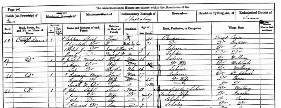
We can use old census information and slightly-less-old maps to draw a picture of where the location might have been. In this example, we used the 1881 OS map (available via Dorset Explorer) of Cann, the 1861 census information, and modern Google maps.
With the person’s name, we were able to find them in the census on Ancestry, and therefore work backwards through the census to see where else the person taking the census went using the schedule numbers. This builds up a picture of a route that the person would have walked, and with a little inference from modern maps we can make a reasonable guess at a solution…
In this particular census return, we learnt that the census taker started at French Mill Lane, travelled across Hawksdeane Lane – where Hawksdeane Farm was; to the Old Turnpike – which we can assume to be the modern roundabout connecting the Salisbury Road into Shaftesbury, Christy’s Lane, and the A350. From there, they travelled south, towards Brinscombe.
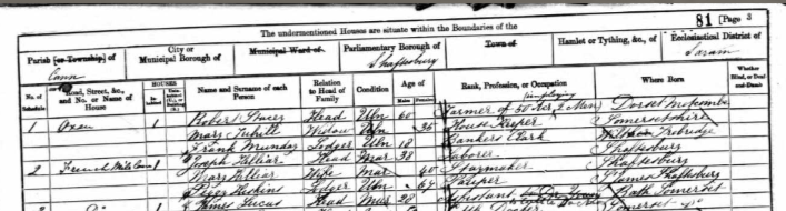
To confirm that this road was the turnpike road, we checked an 1821 plan of the Shaftesbury-Blandford Turnpike road, and this confirms that the turnpike itself was just south of the junction of Hawksdeane Lane, and the road ran almost directly south until it reached the Methodist Chapel, where it veered east, towards Spraggs Mill. This mill does not appear on the later OS Map, but Cann Mill does, which was just west of Spraggs Mill.
Here’s where it gets a little confusing, and some educated guesswork is needed. From the schedule numbers, we know that the surveyor arrived back at Spraggs Mill and Cann Mill after surveying Cross Lane and Long Lane, and at this point it does become more difficult to identify exactly where they may have gone.
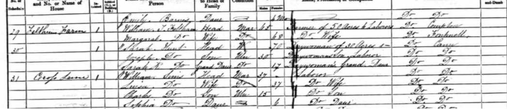
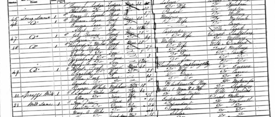
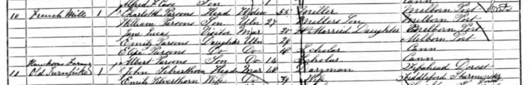
We might guess that the farm identified as ‘Bozley Farm’ on the 1880s map might have been Feltham Farm, though this is unclear. Feltham Farm was presumably named after the owner at the time (William Feltham), so it is likely that the name of the farm changed over time. The suspicion is that Cross Lane may have been what is now known as Foot’s Hill Road.
We think the surveyor may have gone across a footpath and turned left into the road near Bishop’s Farm, which seems to have skirted along a contour of the hill itself. This is identified on the 1880s drawing, running up Foot’s Hill towards Bishops Farm. The surveyor then might have gone across another footpath towards Cann Farm, before turning left back down Long Lane, which still exists as such. This is marked in the below map in blue. That there are three wells (marked by the letter W on the OS map) and buildings identified on this map suggests that they were more than simply farm-buildings attached to Bishop’s Farm. Indeed, given so many of the people living in properties in Cross Lane were labourers, we might guess they worked on Bishop’s Farm.
All of this leads us to draw a map like this:
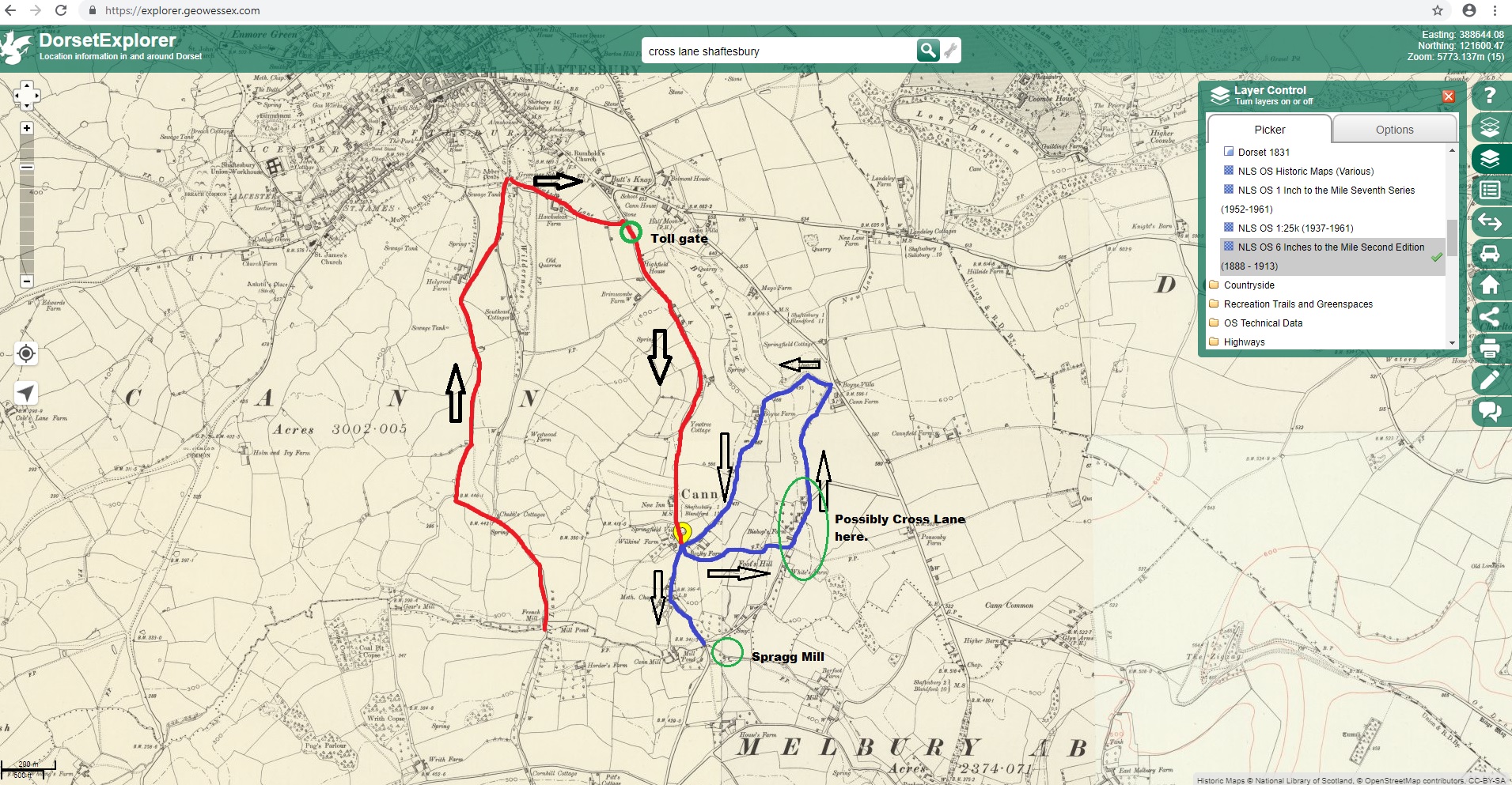
There seems to only be a couple of these buildings which still exist, though the second footpath does still seem to be in place, leading from Foot’s Hill Road to the Higher Blandford Road. Our guess is that the properties which still exist on the Foot’s Hill road might have been the house, although it is possible that that particular building may have been long since destroyed.
—
We hope this gives you an indication of how to ‘use’ census information to locate a building or a property, even if you don’t have a property number or name! A little bit of detective work, some educated guess-work, and comparisons with different maps can often lead to an answer!