
In this guest blog, one of Dorset History Centre’s volunteers, Louise, has taken a look at a recent acquisition made by DHC, and what it tells us about Corfe Castle’s past…
—
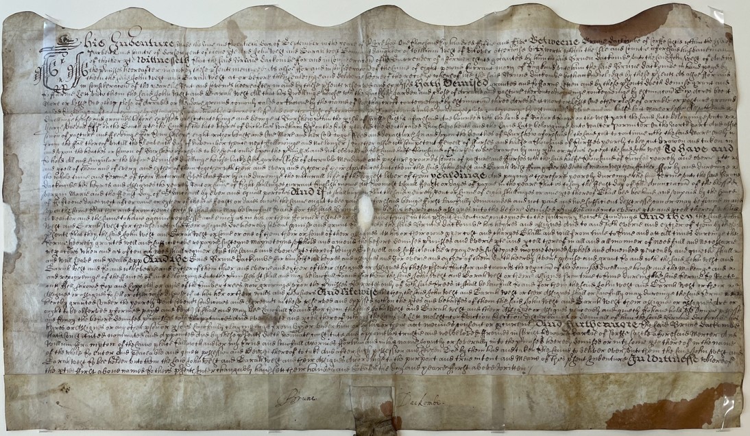
In the parish of Corfe Castle lies a place called Bushey just north of the Studland Road. If you’re a keen walker or cyclist, you will know where it is as it tags onto the southside of the heathland of Wytch and Ower, the perfect place for ramblers and riders. It was originally called Burshew and that name appears on a lease dated 1655 that DHC has just acquired (accession 11580).
It is an exciting lease because:
a) Brune Dackombe’s signature appears on it (he supported the losing side in the Civil War with the consequence that he was fined heavily and the Dackombe family name departs from Purbeck within 30 years of this lease)
and b) it tells exactly who had acquired the land before the Dackombes.
The deed mentions a cottage (no longer in existence) with land adjoining it of 6 acres and various plots of separated land called Westhaycroft of 3 acres, a close of 4 acres and another Close, called Hardinges Close, of 1 ½ acres. It mentions that Burshew Heath lies to the north along with the land belonging to Walter Parmiter. So where was it situated?
Luckily D-RWR/T/32 was able to supply a few answers (admittedly not all as I’ve no idea where the cottage lay). The father of Brune, Edward Dackombe, purchased this exact same premises in 1624 from two brothers, William and Richard Parmiter, for £22. They were the sons of Walter Parmiter, a husbandman from Afflington, and they inherited these lands along with the adjoining fields which they sold to Robert Toop. Their father, Walter, had bought the lands in 1547 from Thomas Hardye and his son, Robert, both of Afflington, which begs the question did Afflington manor extend further north than previously thought?
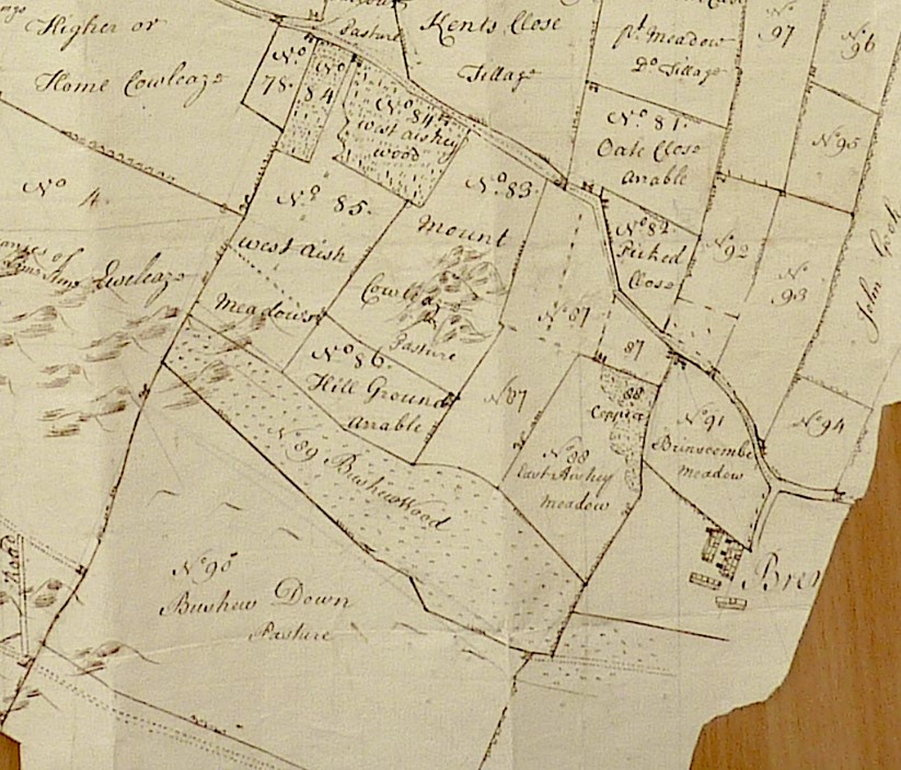
By the time Samuel Donne was drawing up the maps for the Calcraft Estate in 1772, the fields were part of Higher Burshew Farm. Westhaycroft was now called West Aish Meadows forming part of No.85; the 4 acres was called East Aishey Meadow was at No.88; Hardins Close lay opposite Brenscombe Farm at No.94.
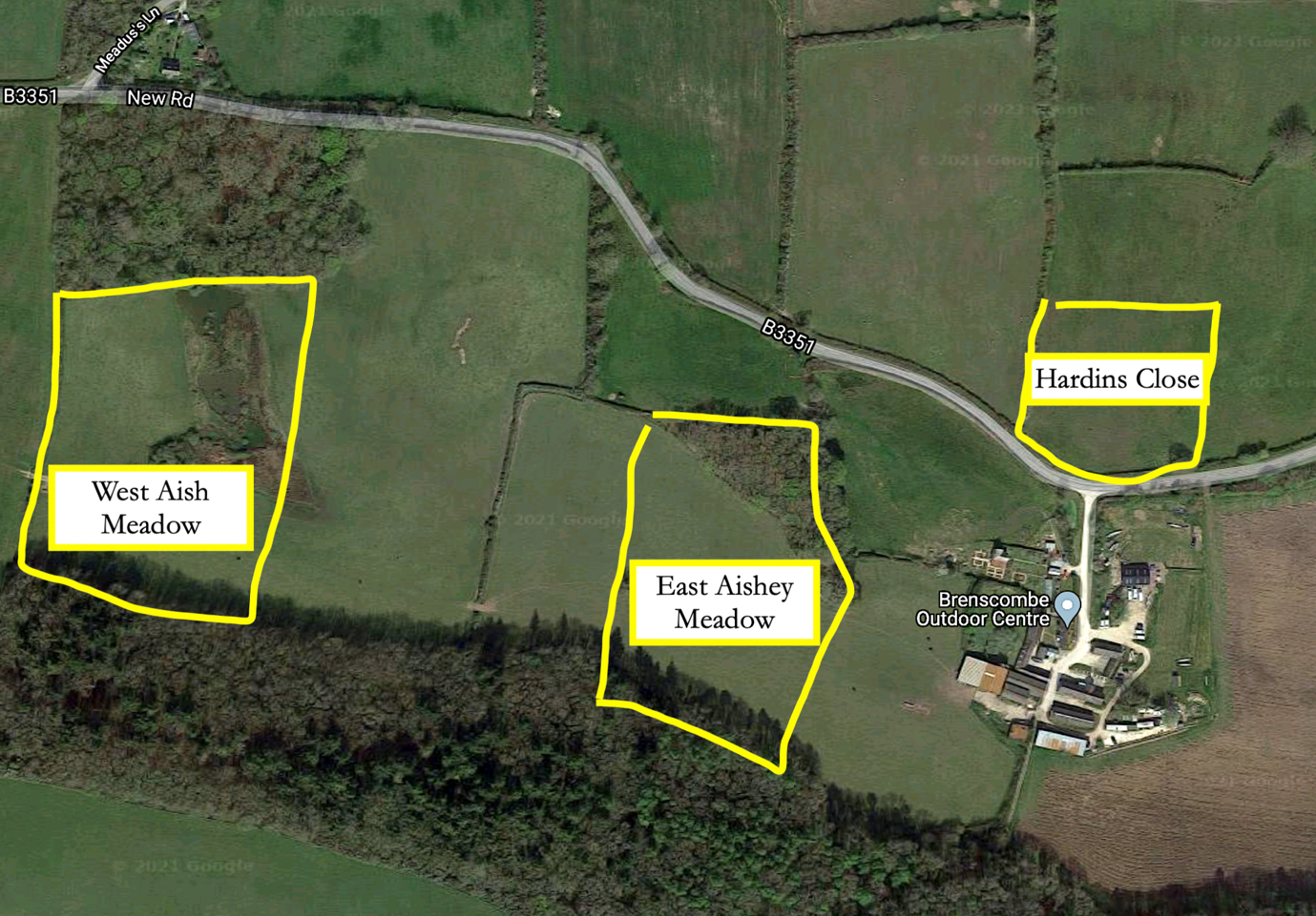
Today the fields have slightly altered as field boundaries have been removed so they are roughly sketched in below. None of the fields are accessible to the public but you can view them from the top of Rollington Down as they lie between Rollington Farm and Brenscombe.
—
This was a guest blog written for Dorset History Centre by Louise Haywood.
If you would like to share some of your archival research, or an interesting story via our blog, please get in touch – archives@dorsetcouncil.gov.uk.
Interesting reading—-am trying to locate an area/ dwelling called Bushy Combe where my ancestors once lived. Can you shed any light on this matter. Would be most grateful if you could.
Hi Edward – we have had a look for a Bushy Combe in Dorset in various sources, including in Hutchins, and the appropriate ‘Place Names of Dorset’ volume, with little success. We have found there is a place in Somerset with the same name, and it’s perfectly possible that there was such a place in Dorset too, but our initial searches have proven fruitless!