
‘Everyone loves a map’ – it’s a common refrain and although we’re sure there are people out there who don’t cherish cartographic items in the way that DHC does, many certainly do like to peruse them in order to gain a sense of where things are and to understand the relationship between places and communities. They can also be beautiful works of art in their own right.
DHC has been fortunate enough to receive several interesting additions to its collection in recent months. These include a huge 1834 map of Sherborne and environs, a small plan of Boscombe in 1872 and a nautical chart of Portland and the Shambles originally drawn in the 17th century.
—
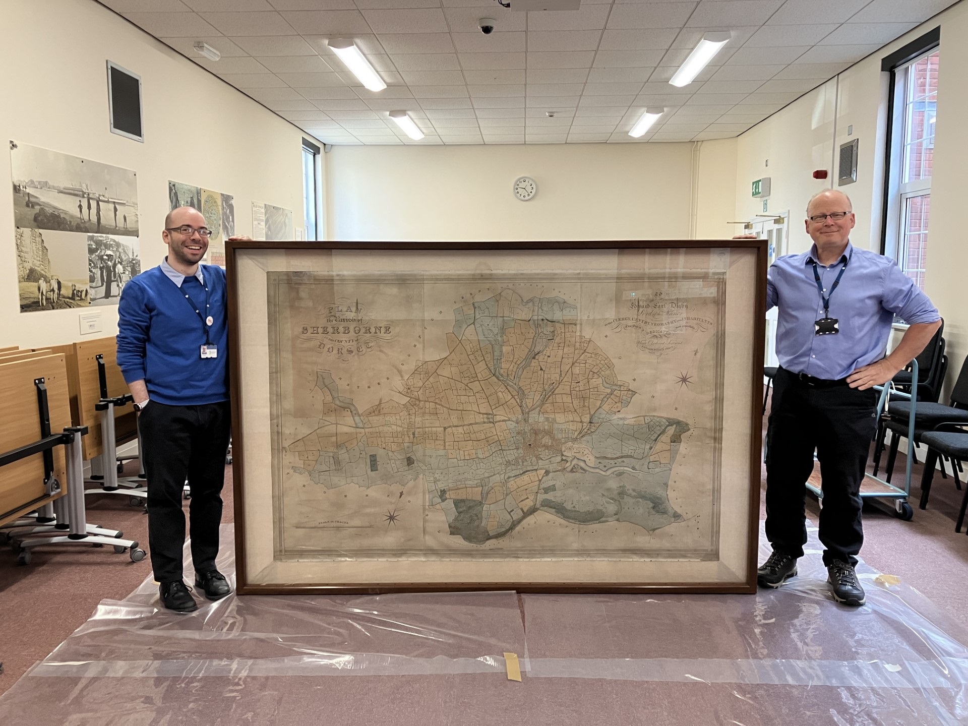
The Sherborne parish map, a beautiful example of its type, was surveyed and drawn by Edward Thomas Percy in 1834. It was gifted to DHC by local solicitors Porter Dodson who could no longer accommodate the huge framed item in their new premises. The map is colour coded: dwelling houses in pink; churches in black; industrial buildings in grey; arable land yellow-brown; and pasture in green.
The map provides researchers with a largescale picture of Sherborne and surrounding rural landscape as it was nearly two hundred years ago. The maps and terrier provide details of land ownership and tenants’ names; they help to identify shops, inns, churches, chapels, schools and evidence of processing and manufacturing (for example, the four silk mills); the maps highlight the number of orchards, gardens and green spaces. Outside the urban boundaries, the topographical features include the racecourse on Lenthay Common and the turnpike road system and toll houses controlling entry to Sherborne – emphasising its function as a market and thoroughfare town.
—
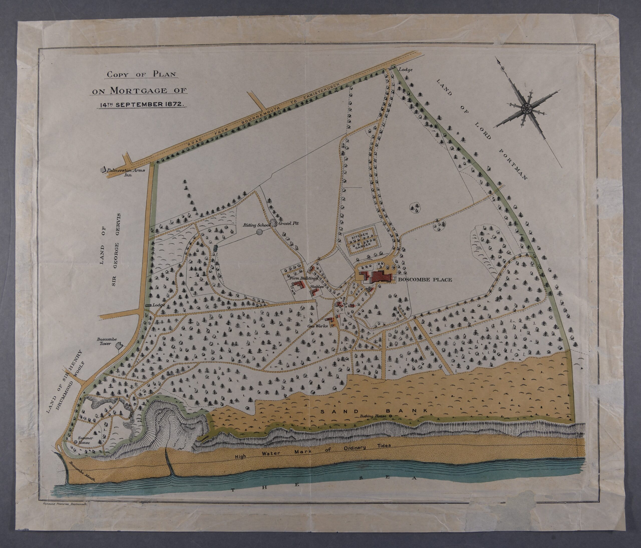
The second recent acquisition is this rather attractive coloured plan of Boscombe in 1872. It was purchased by Dorset Archives Trust at a local auction house along with several other framed items. The plan shows a Boscombe very unlike the place we know today with very little development (the first pier was constructed in 1889) and almost no sign of habitation except for the large property known as Boscombe Manor. The latter began life in 1801 as Boscombe Cottage latterly being purchased by Sir Percy Florence Shelley (son of Mary Shelley) who enlarged and improved the property and built a 200-seat theatre. The property is known locally as ‘Shelley Manor’ to this day. Boscombe formed part of Hampshire until 1974 when along with Bournemouth and Christchurch it was incorporated into Dorset. This small, but attractive piece of local history shows how the place looked in the decades before large-scale development took place and mass tourism changed Boscombe forever.
DHC’s conservator had to extract the plan from its frame where it had been attached with copious amounts of Sellotape (not loved by conservators!) but fortunately this was successfully achieved and the plan is now safely stored in DHC’s environmentally controlled strongrooms.
—
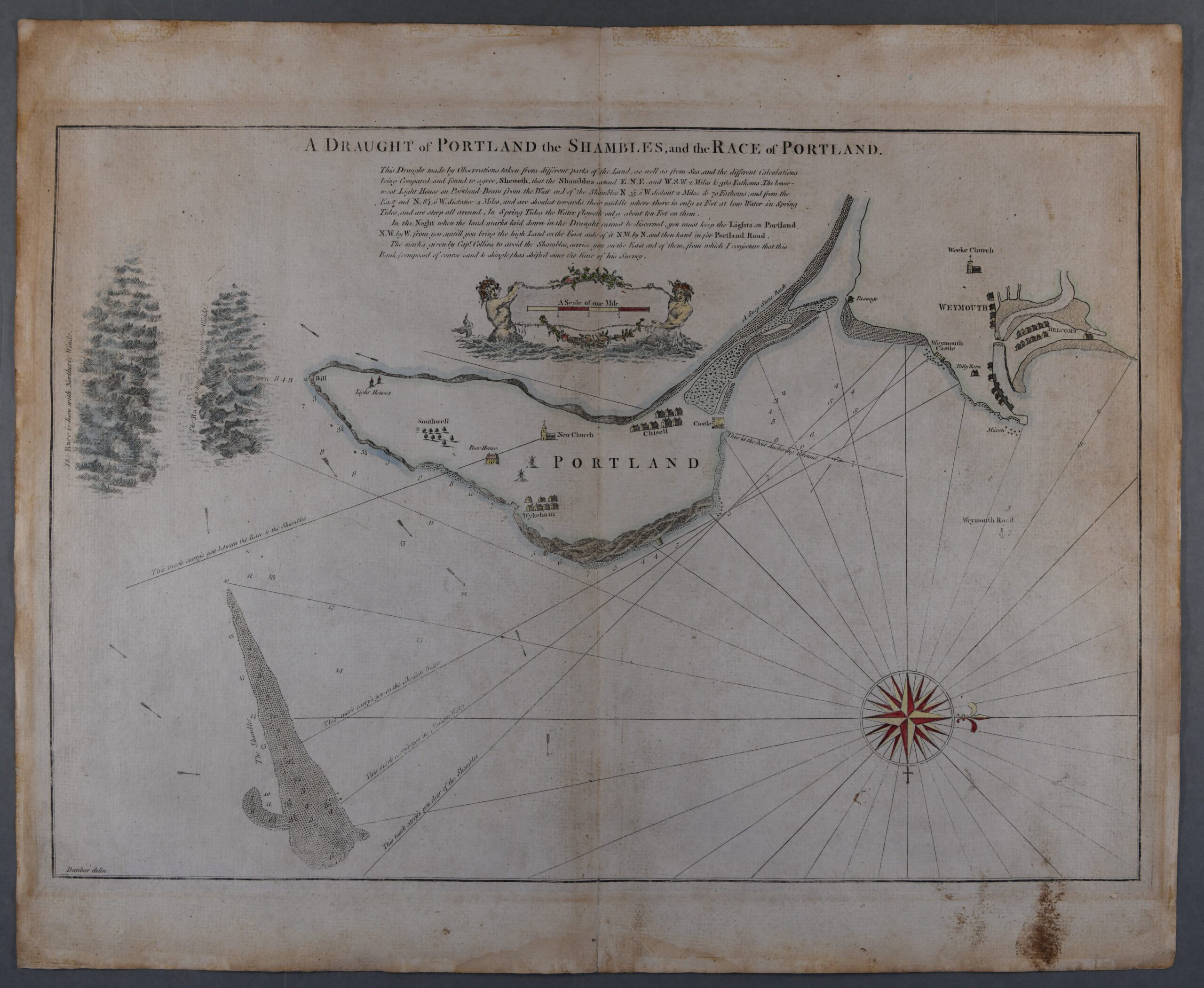
The third new acquisition, another purchase funded by Dorset Archives Trust is a hand-coloured plan ‘A Draught of Portland the Shambles, and the Race of Portland’, late 18th century print of a 17th century original. (DHC reference: M/207)
It was drawn by Captain Greenville Collins. Collins was an important figure in naval history, being a prominent hydrographer, appointed by Samuel Pepys (Secretary to the Admiralty) to chart the coastlines of Britain as part of the modernisation of Britain’s naval defences. The resulting Great Britain’s Coasting Atlas was produced of which this single plan forms part. It has been enhanced with colour and is a particularly attractive version of Collins’s work.
The seas off Weymouth and Portland can be notoriously hard to navigate and many shipwrecks testify to the dangers of sailing in these waters. The chart marks precisely the location of the Shambles – a bank ‘composed of coarse sand and shingle’ that shifts in size and depth subject to the movement of the sea. Also prominently displayed on the plan is the Portland Race – the fast-moving water driven by tidal shifts off the southern point or Bill of Portland. The plan marks the different location of the Race depending on whether the winds are coming from the north or south. The plan in addition to its visual aids also offers a written guide to mariners seeking to navigate the waters off Portland avoiding danger and bringing their vessels safely into harbour.
This plan is an excellent addition to DHC’s holdings and reminds us once again of the county’s important and sometimes tragic maritime history.
DHC holds large numbers of maps, some dating back many centuries. Please consult our online catalogue or talk to our public service team if you’d like to find out more.
[…] the Boscombe Manor estate (now known as Shelley Manor), drawing affluent residents to the area. [1, 2, 3, 4, […]